PARTICIPANT REQUIREMENTS
- ZERO ALCOHOL TOLERANCE. Zero alcohol will be allowed before or during the event. Any alcohol consumption instantly disqualifies the boat, and they forfeit their entry fee, their chance to win prizes and their evening event.
- All participants are to be in U.S.C.G.-approved flotation devices. Drivers are to be tethered at all times while under power.
- All boats will carry all items required to be compliant with all NY State Laws, US, and Canadian Coast Guard regulations.
- All Boats entered will have a large, color-coded entry number on both sides where easily visible.
- All boats will require the Driver or Navigator to have the Safety App downloaded on their phone.
- All boats are required to carry an orange distress flag (provided by the run).
- All Boats will be designated to one of three (3) groups of 30-35 boats, indicated by a specific color for each group.
- All boats are to have a VHF radio and be tuned to the same frequency. Channel 8 has been determined for all participants and an additional alternate channel is assigned for all officials, law enforcement, medical and marshal boats.
- All Drivers and Navigators will be required to attend the Saturday morning drivers meeting.
- Slow and No Wake Zones will be clearly marked on the course map, will be clearly pointed out in the mandatory drivers meeting and will require participants to follow the pace boat in those designated areas. Passing the Pace Boat in a designated slow zone is grounds for immediate disqualification.
- The Pace/Safety boats will each have a large flag on board which will be raised to signal all boats to stop. Otherwise, the Pace boat is only to be followed.
- Anytime there is a Pace boat/Safety boat leading in a designated slow zone, anyone who passes it will be instantly disqualified. Same as above, they forfeit their entry fee, evening event, and the ability to win any prizes.
- The Pace Boat will lead at the start of the event and at all restarts.
- When boats are on plane, they shall be run no closer to each other than 100’
EVENT ROUTE (2024 Route Map)
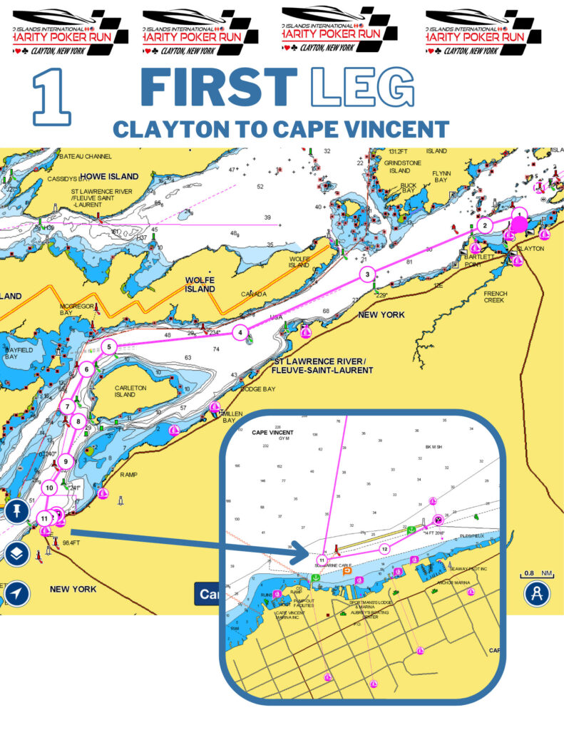
- The staging area for the start of the event will be downriver from the Village of Clayton, near the head of Round Island.
- Boats will be released by radio in their assigned groups (designated by color) at a time after being cleared by a Marshall, on the command on an event official.
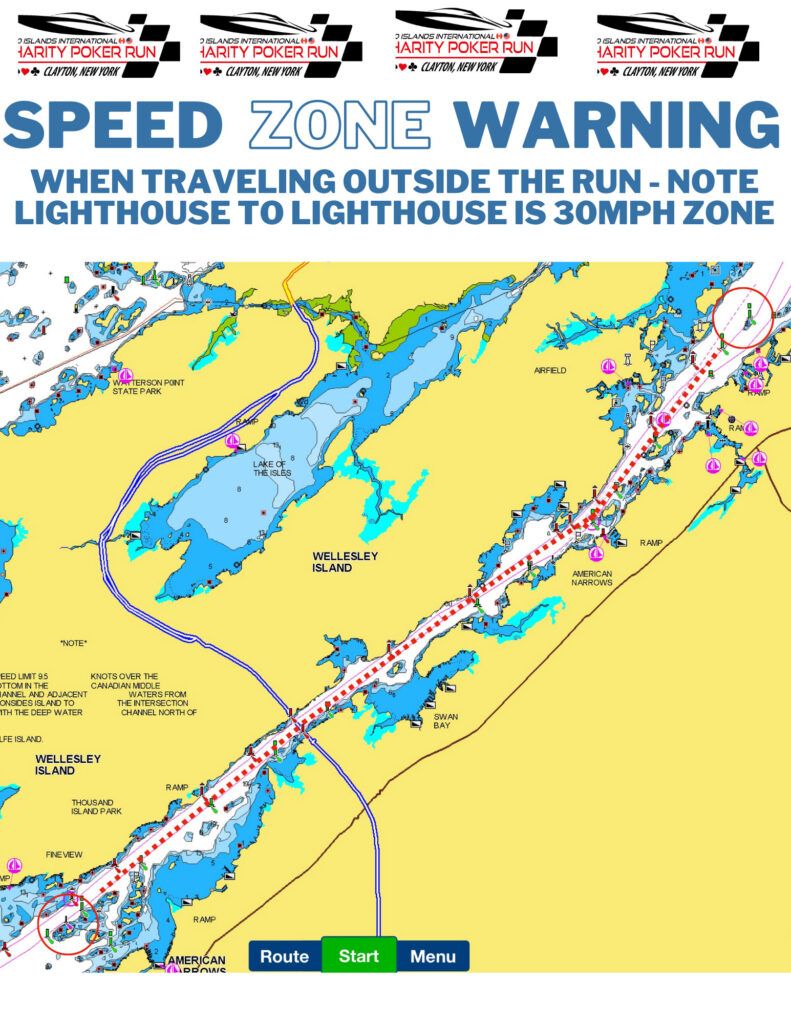
- No boat is to pass the Pace Boat/Safety Boat until after the end of the 30 MPH zone. Passing the Pace Boat in a designated slow zone is grounds for immediate disqualification.
- The Clayton Volunteer Fireboat, “LAST CHANCE” will be spraying its water cannon at Bartlett Point signaling boats are cleared to run to Cape Vincent.
- Upon arrival near Cape Vincent, boats will, of course, decelerate as they get to the 2 marshal boats and pass the Village dock in single file. Boats will be held inside of the break wall in Cape Vincent until all have arrived, thus almost eliminating oncoming traffic. There will not be a card picked up in Cape Vincent for safety reasons.
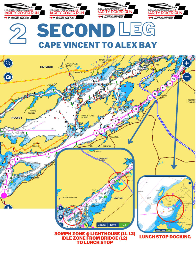
- Boats will be restarted in the same fashion leaving Cape Vincent. Regroup with your pace boat, boats will be released by radio in their assigned groups (designated by color) after being cleared by a Marshall, on the command on an event official.
- As boats return downriver navigating the American Channel passing by Carlton Island, they will again slow down as they approach Bartlett Point.
- As boats travel in front of Clayton this area is designated as a Rooster Tail Zone and speed will be controlled at 60 mph. Upon passing Round Island boat will start to decelerate as they enter the American Narrows and Rock Island Lighthouse boat will be entering a speed zone and boats should fall in behind their pace boats. Fire and Marshall boats will be stationed as to delineate these areas and you will be required to stay behind your Pace Boat in the entire zone.
- There will be marshal & safety boats stationed as the boats travel downriver towards the 1000 Islands Bridge. At this point, again participants are required to travel at speeds no greater than 5 MPH as they traverse the American Narrows.
- At US Coast Guard Station participants will break right and enter the main docks of Alexandria Bay where the lunch stop will occur from noon – 2:00pm.
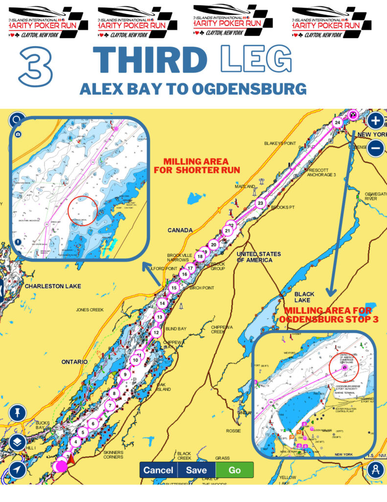
- After the lunch stop boats will proceed to just east of Boldt Castle to Deer Island. Boats will be released by radio in their assigned groups (designated by color) after being cleared by a Marshall, on the command on an event official.
- As you arrive at or about Deer Island you will be released to accelerate all the way to the Brockville Narrows. When approaching the Brockville Narrows, marshal boats will be stationed indicating the 30 mph zone.
- The Brockville Narrows is a designated 30 MPH zone. From there, participants are free to run their boats all the way to Ogdensburg where they will slow down to idle speed when they get to the marshal boats stationed at the entrance to the Port of Ogdensburg. There will not be a card picked up in Ogdensburg for safety reasons.
- Boats will idle and stage just down river from the port and wait for yet another restart. Boats will be released in their assigned groups (designated by color) after being cleared by a Marshall, on the command on an event official.
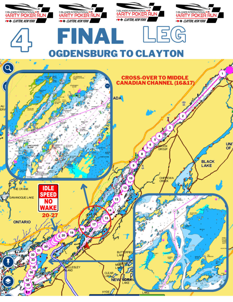
- Returning from Ogdensburg boats will pass through the Brockville Narrows, the narrows are designated as a 30 MPH zone. Once clear of the Brockville Narrows boats a free to run until they reach Whiskey Island, where the Alexandria Bay Fire Boat and Marshall Boats will direct the boats to the North of Wellesley Island heading up the Canadian Channel.
- Boats will travel upriver through the Canadian Channel. A few areas of this part of the river are a 30 mph zone and will be indicated so by the Marshall as you pass under the Canadian span of the 1000 Islands Bridge be boats will be released to run again as they leave that slow zones.
- Boats will approach the head of Wellesley and the foot of Grindstone; this area of the course is fairly narrow and will have spectator boats so watch your speed. In this area the Clayton Fire Boat and Marshall boats will direct boats as they navigate the foot of Grindstone and up through the Picton Islands Channel, eventually returning to Clayton.
NYS laws # 102.1 and # 102.4 will be enforced from Rock Island Light House to Sunken Rock Light House and in the Harbor zones where applicable.
The 1000 Islands Charity Poker Run has met with the USCG, the NYS Park Police, and the NYS Police to review and amend the safety plan as needed.
EMERGENCY CONTACTS & IMPORTANT PHONE #’S
- 911
- Bobby Cantwell: 315-882-3145
- Court Rutherford: 315-440-9266
- 1000 Islands Harbor Hotel: 315-686-1110
- Clayton Harbor Marina (Host): 315-686-6010
- Village Municipal Docks (Boat Launch): 315-686-3451
- TowBoat US: 315-775-4114
- US Customs/Border Patrol: 800-827-2851
BOAT RADIO CHANNELS
- Participants / Marshals – #8
- Admin – #10
- Marina – #71
- Emergency – #16

